Maps and Directions to Windward
|
Another version of the directions below, with photographs of landmarks at each turn, can be found at these links: From the WEST (Portland, OR or Olympia, WA) From the EAST (Boise, ID or Pendelton, OR) From the NORTH (Yakima or Spokane, WA) |
From the West Heading East from Portland OR on Hwy 84
- When you get to Hood River, take exit 64
- Turn left under the interstate.
- Proceed through the 4-way stop towards the toll booth. The toll for a passenger car is US$ 2.00
- After you cross over the Columbia river, you'll come to another "T" intersection. Turn right (east) onto Highway 14.
- After you pass through Bingen, continue east along the river for 9 miles. Just before you enter the town of Lyle, you'll cross the Klickitat River.
- Just after the bridge, turn left onto Highway 142 North.
- Continue along the Klickitat river, passing through the town of Klickitat.
- After you pass Mile Post 16, go another half mile, and ...
- Turn left onto Wahkiacus Heights Road [pronounced Wah-ki-a-cus]
- As you make the turn, you'll see the first Windward sign.
- Proceed on up Wahkiacus Heights Road for 3.5 miles. It's steep in places, but it does offer some great views. Watch for downhill traffic.
- Continue past Long Rd.
- Turn left onto Herland Way.
- Continue across the creek bed, merge with Windward Lane, go half-way up the grade, and turn right into the landing area.
- Please honk your horn to let us know that you've arrived.
From the East (Boise, Idaho for example), you'll want to take I-84 to The Dalles, Oregon.
- Just as you get to The Dalles, you'll exit and cross over the bridge to the Washington side of the Columbia River.
- After crossing the bridge, the road goes north for 3 miles before it dead ends into Highway 14. Turn left and head west for some seven miles towards Lyle.
- After you pass through the two short tunnels, proceed on through Lyle.
- As you leave Lyle, turn right on Highway 142 North.
- Continue along the Klickitat river, passing through the town of Klickitat.
- After you pass Mile Post 16, go another half mile, and ...
- Turn left onto Wahkiacus Heights Road [pronounced Wah-ki-a-cus]
- Proceed on up Wahkiacus Heights Road for 3.5 miles. It's steep in places, but it does offer some great views. Watch for downhill traffic.
- Go past Long Rd.
- Turn left onto Herland Way.
- Continue across the creek bed, merge with Windward Lane, go half-way up the grade, and turn right into the landing area.
- Please honk your horn to let us know that you've arrived.
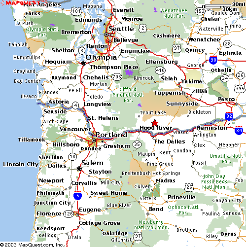 |
From The North
(primarily the central Washington basin or Seattle via Interstate 90),
you'll want to take Highway 97 south out of Toppenish.
Remember, there's no gas for sale between Toppenish and Goldendale.
| Note: from the intersection of I-5 and I-90 (between Seattle and Tacoma), there's only a few miles difference overall between going east to Ellensburg and then south through Yakima, or going south to Portland and then east through Hood River. It's your choice, since either road is good. |
As you approach Goldendale, watch for Highway 142 West It'll be on your right.
- Proceed through the four-way stop, and continue west on 142. Highway 142 winds westward across the terrance for a dozen miles before heading down into the Klickitat River Canyon.
- Pass Mile Post 17 and go another half mile.
- Turn right onto Wahkiacus Heights Road [pronounced Wah-ki-a-cus]
- Proceed on up Wahkiacus Heights Road for three and a half miles. It's steep in places, but it does offer some great views. Watch for downhill traffic.
- Go past Long Rd.
- Turn left onto Herland Way.
- Continue across the creek bed, merge with Windward Lane, go half-way up the grade, and turn right into the landing area.
- Please honk your horn to let us know that you've arrived.